
As the fierce and dangerous coronavirus pandemic leaves a deadly trail behind, it also reveals significant and concerning gaps in official statistics and data. Through it all, individuals from government officials and healthcare professionals to residents have turned to maps to make sense of this uncertainty. They are also using maps to focus as well as target response efforts, and to provide a reliable platform for collaboration.
Throughout COVID-19, most of us have become quite familiar with stories of social isolation, quarantine, and sacrifice, or the brave and heroic healthcare professionals fighting on the front lines. A less-often told story is that of large groups of GIS (geographic information systems) professionals helping coordinate response efforts.
There is no doubt that GIS is demonstrating its incredible power during COVID. Did you know that integrating geospatial data with relevant statistics can help understand and evaluate the transmission and spread of a viral contagion? Note that this also makes it an excellent tool for decision making in both the short and long term.
We can argue that geospatial data is now at the core of how most states in the US are responding to the COVID-19 pandemic.
What is Geospatial Data?
We can define geospatial data as data that is ‘geotagged’ or ‘geocoded’ to a location. It is possible to remotely sense this information from space through satellite imagery, and it can also be curated from surveys, databases, and project documents.
GIS and COVID-19
It is pleasing to see that the GIS community has sprung into action during COVID-19. From global bodies like the World Health Organization, to local governments, academics, and hospitals, GIS is being leveraged to effectively communicate heavy data sets to the general public, and to analyze the numbers in detail.
This analysis allows for the creation of reliable forecasting tools that will help policymakers adequately prepare for what’s to come as well as allocate resources appropriately. Once professionals understand and model the dynamics of a disease, they can use satellite imagery and other datasets representing data geocoded to locations to accurately monitor places where the disease may potentially emerge.
Helps the Public Evaluate Risk
With limited and ever-changing information on this virus, it can be quite difficult to assess the risks of exposure at the community level much less across the world. Maps can play an important role in crafting a shared narrative in a health crisis.
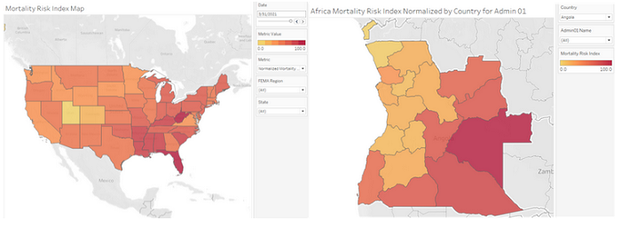
For example, using the CDC’s SVI (Social Vulnerability Index), government can use maps and geospatial data not only for emergency preparedness and emergency response services, but for effectively communicating with residents. The SVI helps residents understand the various challenges and issues faced by their neighbors, helping inspire and strengthen a sense of shared responsibility in the face of a shared emergency.
Using a modified version of this SVI, a Mortality Risk Index has been created that identifies risk levels from COVID-19 nationally (Figure 1).
Susceptibility to Socioeconomic Impacts
It is no secret that the impacts of COVID-19 go beyond public health concerns and have triggered prolonged economic hardships. This is why it is essential to identify the populations residing in regions hit hard by the health pandemic to offer targeted support.
It is clear that we have to generate pandemic tracking at multiple geospatial scales to support decision makers within their respective spheres of influence. For example, city officials are mainly interested in what’s happening in the city. High-resolution maps identifying areas of risk can help inform a targeted response such as localized quarantine measures designed to contain the spread of the disease. This can be done at the state level as well as the neighborhood level. By layering various vulnerability and risk maps, decision-makers can craft nuanced responses, channeling their resources to particular areas with the direst needs.
Helps Residents Locate Essential Services and Resources
Because of business closures and significant reduction in many critical services, like public transit, it has been quite challenging for essential workers in the US to get around. It is also difficult for everyday people to access essential resources they need, such as food.
Dynamic maps informed by geospatial data can be important tools for keeping residents informed about business closures and operating hours during the pandemic, as well as where they may find food and other necessities.
For example, Baltimore developed the COVID-19 Asset Map in order to help local residents, especially those with a lower socioeconomic status, locate critical services and resources such as senior food distribution sites, and primary care health facilities for the uninsured.
“Every cloud has a silver lining”, as the old adage goes, and the rise of GeoHealth technologies is certainly a shining strand of silver. The GIS community’s response to date to a truly unprecedented pandemic has been commendable and there is every indication that more is on the way.
About the Author

Ajay K. Gupta, CISSP, MBA, CEO, HSR.health (with insights from Jean F. Teotonio, MD, Public Health Analyst). Over a 20-year career in cybersecurity and information technology, Ajay has seen companies create true competitive advantage from successful management of security and technology initiatives. At the same time, healthcare is burdened with outdated technology infrastructure and inefficiencies — which are often measured in human lives. Ajay decided to take his understanding of technology and implementation to disrupt and innovate healthcare.
In launching HSR.health, Ajay leverages the best of tech to transform American healthcare into a system that innovates healthcare delivery achieving improved quality, lower costs, and health equity. Under Ajay’s leadership, HSR.health pivoted to support COVID response in the US and globally. And through its lessons learned has developed insights into how health risks impact broader markets. The company is developing a digital Pandemic Early Warning and Response Platform to identify and mitigate impact of future pandemics.
Sign up for the free insideBIGDATA newsletter.
Join us on Twitter: @InsideBigData1 – https://twitter.com/InsideBigData1


Speak Your Mind